Berlin Schönefeld Airport (SXF)
Orientation and Maps
(Berlin, Germany)
Berlin is the vibrant capital city of Germany and covers a vast area. Following the unification of the city at the end of the 1980s, Berlin has flourished and the city you see today is modern, exciting and most of all, appealing.
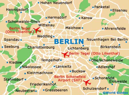
Each year, thousands of tourists visit Berlin, to see the sights, visit the attractions, enjoy the nightlife and dine at the endless selection of restaurants. Berlin is also an important city of finance and regularly attracts businessmen from all over Europe. With three separate airports, all within easy reach of the city, Berlin Schönefeld Airport (SXF) is the furthest of the three and lies on the south-western outskirts.
The public transportation network in Berlin is modern and in-keeping with the city, comprising buses, trams and an electric underground train system.
Berlin Schönefeld Airport (SXF) : Important City Districts
Although Berlin is now completely unified, two main central areas still continue to exist, known as CityEast and CityWest. Unter den Linden is one of the most trendy parts of the historic old city and has become a particularly fashionable avenue. This area leads to the Karl-Liebknecht-Strasse, to the east of the city's famous Brandenburg Gate.
To the south of this region you will find the exciting Potsdamer Platz, which has become an iconic symbol of 'New Berlin'. Highlights at the Potsdamer Platz include a vast shopping mall in the DaimlerCity area, and the eye-catching Sony Centre.
Germany Map

Berlin Map